Loading page…
CAD Drawing
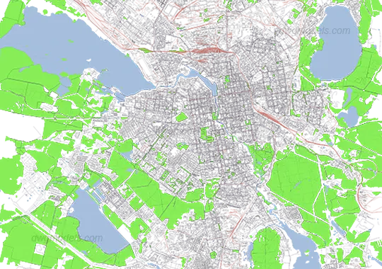
Ekaterinburg City Urban Map CAD Drawing
by Kevin Hennessey
About this asset
Detailed 2D urban map of Ekaterinburg provided as an AutoCAD DWG drawing, featuring street networks and green space boundaries. This comprehensive 2D CAD map provides a top-down view of the city of Ekaterinburg. The drawing delineates complex street networks, arterial roads, and urban blocks alongside significant natural features including water bodies and green zones. The data is presented as a clean vector-based layout, suitable for site analysis or large-scale master planning documentation. Graphic representation uses distinct line weights and filled regions to differentiate infrastructure from natural topography. All geometry is clearly defined, allowing for easy selection and modification of individual layers to suit specific project requirements within a standard CAD environment.
The download is a 7.8 MB file containing an AutoCAD drawing (.dwg) drawn in plan. It opens in AutoCAD, BricsCAD, DraftSight and other DWG-compatible CAD programs, ready to insert as blocks into plans and elevations.
Professionals can insert this file directly into an existing project coordinate system to serve as a base for master planning or site analysis. The drawing is organised into logical layers, enabling users to isolate road networks, water bodies, or building footprints for specific presentation needs. It is best practice to verify the scale upon insertion and use the geometry as a reference layer to establish site boundaries or surrounding context in early-stage urban design proposals.
This asset is essential for urban planners, landscape architects, and civil engineers working on site feasibility studies, infrastructure planning, or large-scale development projects within the region. It serves as a reliable foundation for contextual mapping in architectural presentations, environmental impact assessments, and municipal planning reports. When paired with topographical data, it facilitates a comprehensive understanding of the urban fabric. Search for this file when requiring accurate city layouts, regional base maps, or geometric references for broad-scale architectural and engineering project site documentation.