Loading page…
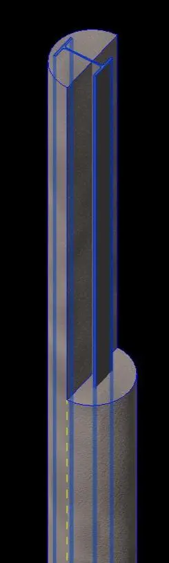
Revit Family
Soldier Pile V2
by Nicholas Feihel
About this asset
Soldier Pile V2 is a Revit family representing a structural earth-retention element featuring a steel H-beam embedded in concrete. This soldier pile component consists of a central steel H-beam profile encased within a cylindrical concrete shaft. The design reflects standard civil engineering practices for deep foundation systems and vertical shoring walls. The geometry clearly indicates the interface between the structural steel core and the surrounding concrete encasement, providing an accurate representation for section cuts and structural coordination. The model is presented with clean, sharp edges, suitable for detailed documentation of excavation support systems or permanent basement wall foundations where vertical load-bearing capacity and lateral soil pressure resistance are critical project requirements.
The download is a 481 KB file containing a Revit family (.rfa). Load it into a project from the Insert tab with Load Family, then place it like any other component of its category; it schedules and tags with the rest of your model.
In Revit, this family is typically deployed as a structural column or generic model component. Users can place the pile along a grid line or manually specify coordinates to define the shoring alignment. Because it is a native family, the material parameters for the steel and concrete can be mapped to project-specific libraries for accurate quantity take-offs. The visibility settings allow for adjustment between coarse, medium, and fine detail levels to maintain model performance when displaying large arrays of piles in a complex foundation plan.