Loading page…
Revit Family
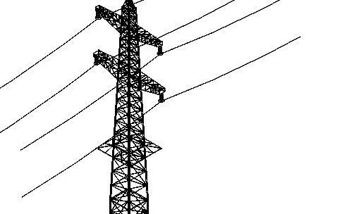
High Voltage Electricity Transmission Tower with Three Arms
by Daniel Lee
About this asset
This Revit family provides a high-voltage electricity transmission tower featuring three structural arms for overhead power line support. Constructed as a classic lattice-style utility structure, this transmission tower is engineered with a tapered vertical profile to ensure structural stability against wind loads. It features three distinct horizontal arm assemblies designed to hold power line insulators at varied heights. The geometry is defined by a dense crisscross steel framework, typical of high-voltage infrastructure. The model captures the industrial aesthetic of galvanised steel utility poles, providing a realistic representation of electrical grid hardware. It is designed for site-wide visualisations, capturing the scale and presence of overhead power distribution systems in rural or industrial environments.
The download is a 1.2 MB file containing a Revit family (.rfa). Load it into a project from the Insert tab with Load Family, then place it like any other component of its category; it schedules and tags with the rest of your model.
In Revit, this family is typically placed within a site plan or a topographical model to establish utility corridor routes. Users should manage the visibility of the complex lattice geometry by assigning it to a specific sub-category or workset, as the fine-detail lines can impact viewport performance. It is best used as a proxy for site context, allowing designers to check for clearance requirements and visual impact within the surrounding terrain or landscape design projects.