Loading page…
Revit Family
Spot Elevation Annotation Symbol with Editable Text
by Angela Mayrina
About this asset
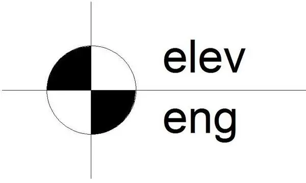
This Revit annotation family provides a clear spot elevation symbol with customizable fields for architectural and engineering values. This technical annotation symbol features a classic circular quadrant marker, split into alternating black and white segments to ensure high contrast against any drawing background. It includes two distinct text placeholders, labelled for architectural and engineering elevation data respectively, allowing for precise site documentation. The crosshair extends beyond the circular bounds, providing clear alignment for accurate placement on floor plans, site layouts, or section details. Its clean, vector-based geometry ensures that the symbol remains crisp and legible at any scale, maintaining professional standards across all construction documentation sets and technical drawing sheets.
The download is a 143 KB file containing a Revit family (.rfa). Load it into a project from the Insert tab with Load Family, then place it like any other component of its category; it schedules and tags with the rest of your model.
Load this RFA file directly into your Revit project as a generic annotation or spot elevation tag. Once placed, users can edit the instance parameters to input specific numerical values for both architectural and engineering levels. The family is designed to be scale-independent, meaning it will automatically adjust its display size according to the view scale settings of the sheet, ensuring consistent readability without requiring manual resizing or complex adjustments to the family geometry.